Adilabad
Town in the forested north of Telangana, also called Edlabad, head of the district formed in 1905 from the old Sirpur Tandur sub-district of the Nizam's Dominions. The Imperial Gazetteer of 1909 describes a thinly peopled, unsurveyed land of forests, Gond villages, cotton and Telugu and Marathi speech, without a railway or metalled road; the census of 1931 records rapid road building there.
Adilabad is a town in the far north of Telangana. Under the Nizams it became the head of a new district in 1905.1 The district was mostly forest, and the Imperial Gazetteer of India volume on Hyderabad (1909) calls it the most unhealthy in the state.1
From Sirpur Tandur to Adilabad
Before 1905 the area was the sub-district of Sirpur Tandur, also called the Amaldari.2 The gazetteer describes how it took shape:34
- Before 1866, the revenue of the Edlabad and Sirpur taluks was farmed out.3
- In 1866 these two taluks were put in Indur (now Nizamabad) district.3
- In 1867 they moved to Elgandal (now Karimnagar) district, and in 1869 back to Indur.4
- In 1872 the state took back the jagir (land grant) of Rajura and made the three taluks into a sub-district.4
In 1905 the sub-district became the district of Adilabad.5 It gained Nirmal and Narsapur taluks from Indur, and Chinnur and Lakhsetipet from Elgandal.5 Two new taluks, Kinwat and Jangaon, were formed.5 The district then had eight taluks.2
Land and people
The gazetteer says the Satmala range ran through the district for about 175 miles.1 Teak, ebony and other trees grew to a great height.1 In 1901 the old sub-district had 272,815 people.5 About 44 per cent spoke Telugu and 28 per cent Marathi.5 About 11 per cent were Gonds, whom the census counted as “Animists”.5 Of the larger district of 1905, more than 10 per cent of the people were Gonds.2
The gazetteer says that at one time Rajura taluk belonged to a Gond Raja and later passed to the Bhonsles.6 It adds that the fort of Manikgarh was said to have been built by a Gond Raja.6 An old temple on the Mahur hill sheltered 400 gosains (Hindu ascetics) and their head.6
Farming, forests and floods
The sub-district had never been surveyed.7 Only a small part of its land was farmed.7 The chief crop was jowar (sorghum), with cotton and oilseeds for sale.7 Forests covered more than 4,000 square miles.7 In 1901 timber sales earned Rs 25,200.7
Coal was found near Sasti in Rajura taluk.3 Trial digging in 1874–75 gave poor results and was given up.3 In September 1891 the Penganga rose in flood for three days and swept away most of the villages on its banks.6
The gazetteer says no railway or metalled road had been made in the sub-district.3 From Edlabad to Rajura and Sirpur there was only a cart track.3 The census of 1931 records a great change.8 Between 1921 and 1931 Adilabad district gained 182 miles of new metalled roads.8
Famine and relief
The gazetteer has no record of famine in the area.3 In 1900, when famine struck the west of the state, people from other districts and from British territory crowded in.3 A poorhouse was opened at Edlabad for 800 people.3 It cost the state only Rs 2,982.3 In 1918–20 Adilabad was one of eight districts partly struck by famine.9
The town
Adilabad town had 6,303 people in 1901.10 It had the offices of the First Talukdar (district officer), the police, customs and forests, a dispensary, a post office and a school.10 It also had a Hindu temple with a yearly fair, and a busy grain market.10
When the four subas (divisions) were reorganised in 1929, Adilabad was placed in the Warangal suba.11 See also Nirmal.
Footnotes
-
Imperial Gazetteer of India: Hyderabad State (1909), p. 184 (archive.org (opens in a new tab)). ↩ ↩2 ↩3 ↩4
-
Imperial Gazetteer: Hyderabad (1909), p. 185 (archive.org (opens in a new tab)). ↩ ↩2 ↩3
-
Imperial Gazetteer: Hyderabad (1909), p. 189 (archive.org (opens in a new tab)). ↩ ↩2 ↩3 ↩4 ↩5 ↩6 ↩7 ↩8 ↩9 ↩10 ↩11
-
Imperial Gazetteer: Hyderabad (1909), p. 190 (archive.org (opens in a new tab)). ↩ ↩2 ↩3
-
Imperial Gazetteer: Hyderabad (1909), p. 187 (archive.org (opens in a new tab)). ↩ ↩2 ↩3 ↩4 ↩5 ↩6
-
Imperial Gazetteer: Hyderabad (1909), p. 186 (archive.org (opens in a new tab)). ↩ ↩2 ↩3 ↩4
-
Imperial Gazetteer: Hyderabad (1909), p. 188 (archive.org (opens in a new tab)). ↩ ↩2 ↩3 ↩4 ↩5
-
Census of India 1931, Vol. XXIII, Part I (1933), p. 29 (archive.org (opens in a new tab)). ↩ ↩2
-
Report on the Famine Relief Operations in H.E.H. the Nizam’s Dominions during 1918–19 and 1919–20 (1923), p. 1 (archive.org (opens in a new tab)). ↩
-
Imperial Gazetteer: Hyderabad (1909), p. 192 (archive.org (opens in a new tab)). ↩ ↩2 ↩3
-
Census of India 1931, Vol. XXIII: H.E.H. the Nizam’s Dominions, Part I: Report (1933), p. 1 (archive.org (opens in a new tab)). ↩
Photos
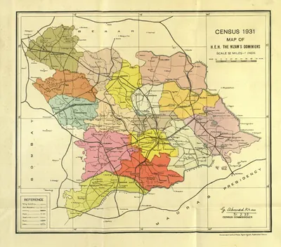 "Census 1931 Map of H.E.H. the Nizam's Dominions" (coloured) (Census of India 1931, Hyderabad, folding map, PDF p. 3)Map · 1933
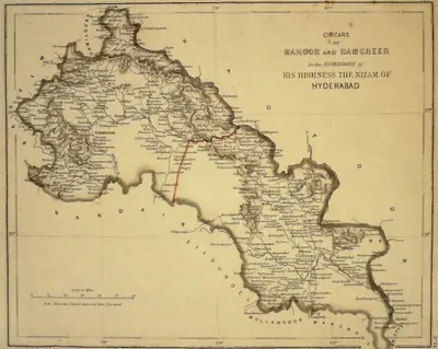 "Circars of Mahoor and Ramgheer, in the Dominions of His Highness the Nizam of Hyderabad" (map No. 14, atlas presented to the Nizam, 1865), noted on the map as not yet surveyedMap · 1865
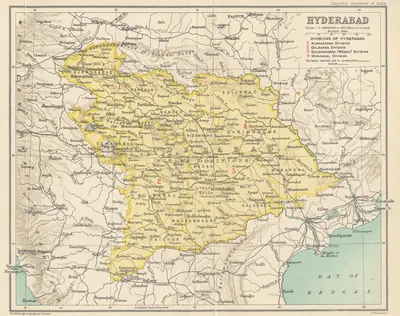 Hyderabad State (Imperial Gazetteer, 1909)Map · 1909
References
Notes (0)
Sources (3)
Spotted an error on this page? Tell us
Last updated: