Mahbubnagar
Town in south-western Telangana, formerly called Palmur, head of a district of the Nizam's Dominions formerly known as Nagar Karnul. The Imperial Gazetteer of 1909 describes a Telugu-speaking district on the Krishna, with the samasthans of Wanaparthy, Gopalpet and Jatprole, the silk weavers of Narayanpet, a revenue survey that doubled the recorded farm land, and the great famine of 1876–78.
Mahbubnagar is a town in the south-west of Telangana. Under the Nizams it was the head of a district that reached the Krishna river in the south.1 The town was formerly called Palmur.2 The gazetteer of 1909 says the district was formerly called Nagar Karnul.1
The district in 1909
The Imperial Gazetteer of India volume on Hyderabad (1909) gives the district 705,725 people in 1901.3 About 86 per cent spoke Telugu, 6 per cent Urdu and nearly 5 per cent Kannada.3 The gazetteer says little is known of its early history.4 It records that the Rajas of Warangal once ruled it, then the Bahmani kings, and later the Qutb Shahis and the Adil Shahis of Bijapur.4
Old forts stood across the district.3 The gazetteer says Ibrahim Qutb Shah built the fort of Koilkonda.3 The hill fort of Pangal, in Nagar Karnul taluk, had seven walls and a citadel.2 Nizam Ali Khan lived in one of its buildings from 1786 to 1789.2 See Nizam Ali Khan.
Three samasthans (tributary estates of Hindu chiefs) lay in the south-west of Nagar Karnul taluk: Wanaparthy, Gopalpet and Jatprole.5 In 1901 Wanaparthy had 124 villages and Jatprole 89.5 See Wanaparthy, Kollapur (the seat of Jatprole) and Amarchinta.
Work and trade
Weavers in Narayanpet made silk saris and dhotis with gold borders.6 These were sent to Pune (then Poona), Solapur, Bombay and Baroda.6 Narayanpet had 12,011 people in 1901, more than the district headquarters.2 It was joined to Saidapur station on the Great Indian Peninsula Railway by a feeder road 21 miles long.2 Coarse paper was once made in Koilkonda and Mahbubnagar taluks, but the gazetteer says cheap imported paper had ended the trade.6
The Great Indian Peninsula Railway crossed only the south-western corner of the district, with one station.7 The main road from Hyderabad to Kurnool, 112 miles long, ran through the district.7 The census of 1931 notes that all the roads of Mahbubnagar were still unmetalled (without a hard stone surface).8
Revenue survey and settlement
Before 1866 the taluks were let out to revenue farmers, who kept two annas in each rupee they collected.79 Some taluks had been held by Arab and Pathan commanders (jamadars) in place of pay for troops.7 When districts were formed in 1866 the farming system ended.9
The survey of the district was finished in 1894.9 Mahbubnagar and Narayanpet taluks were settled in 1900, and the rest in 1903.9 The survey found 981,029 acres in the farmers’ holdings.9 The old accounts had shown only 455,461 acres.9 The land revenue rose by 2.6 lakhs of rupees, or 21 per cent.9 Local boards (district and taluk councils for roads and schools) were set up in 1895.9
Famines
The gazetteer says thousands of people died in the district in the great famine of 1876–78.7 Jowar (sorghum, the main food grain) then sold at three seers to the rupee.7 The famines of 1897 and 1900 hit the district lightly, and only Rs 2,700 was spent on relief.7 The census of 1931 names Nagarkurnool (the present Mahbubnagar district) among the worst-hit areas in the famine of 1871.10 Mahbubnagar was also one of eight districts partly struck by the famine of 1918–20.11 In 1921 parts of it were declared famine-stricken.12
The changes of 1905
In 1905 the state redrew its districts.3 Ibrahimpatan taluk went to Medak, and 73 villages went to Gulbarga district.3 Koilkonda, Jedcherla and Narayanpet taluks were merged into their neighbours.13 The district was left with six taluks: Mahbubnagar, Kalvakurti, Amrabad, Nagar Karnul, Makhtal and Pargi.13 In the census of 1931 it belonged to the Medak suba (division).14
The 1930s and 1940s
Sarojini Regani’s history of the freedom movement is written from the Congress side.15 She says that 120 students of the Mahbubnagar high schools were struck off the rolls in December 1938 for joining a students’ strike.15 She also writes that during the troubles of 1947–48 the tahsildar (taluk officer) of Gadwal fired on villagers who refused to pay a levy, and four people died.16
Footnotes
-
Imperial Gazetteer of India: Hyderabad State (1909), p. 141 (archive.org (opens in a new tab)). ↩ ↩2
-
Imperial Gazetteer: Hyderabad (1909), p. 150 (archive.org (opens in a new tab)). ↩ ↩2 ↩3 ↩4 ↩5
-
Imperial Gazetteer: Hyderabad (1909), p. 143 (archive.org (opens in a new tab)). ↩ ↩2 ↩3 ↩4 ↩5 ↩6
-
Imperial Gazetteer: Hyderabad (1909), p. 142 (archive.org (opens in a new tab)). ↩ ↩2
-
Imperial Gazetteer: Hyderabad (1909), p. 149 (archive.org (opens in a new tab)). ↩ ↩2
-
Imperial Gazetteer: Hyderabad (1909), p. 145 (archive.org (opens in a new tab)). ↩ ↩2 ↩3
-
Imperial Gazetteer: Hyderabad (1909), p. 146 (archive.org (opens in a new tab)). ↩ ↩2 ↩3 ↩4 ↩5 ↩6 ↩7
-
Census of India 1931, Vol. XXIII, Part I (1933), p. 29 (archive.org (opens in a new tab)). ↩
-
Imperial Gazetteer: Hyderabad (1909), p. 147 (archive.org (opens in a new tab)). ↩ ↩2 ↩3 ↩4 ↩5 ↩6 ↩7 ↩8
-
Census of India 1931, Vol. XXIII, Part I (1933), p. 19 (archive.org (opens in a new tab)). ↩
-
Report on the Famine Relief Operations in H.E.H. the Nizam’s Dominions during 1918–19 and 1919–20 (1923), p. 1 (archive.org (opens in a new tab)). ↩
-
Census of India 1931, Vol. XXIII, Part I (1933), p. 20 (archive.org (opens in a new tab)). ↩
-
Imperial Gazetteer: Hyderabad (1909), p. 144 (archive.org (opens in a new tab)). ↩ ↩2
-
Census of India 1931, Vol. XXIII: H.E.H. the Nizam’s Dominions, Part I: Report (1933), p. 1 (archive.org (opens in a new tab)). ↩
-
Sarojini Regani, Highlights of the Freedom Movement in Andhra Pradesh, p. 186 (archive.org (opens in a new tab)). ↩ ↩2
-
Regani, Highlights of the Freedom Movement, p. 221 (archive.org (opens in a new tab)). ↩
Photos
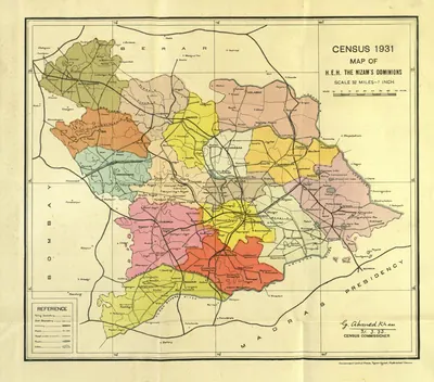 "Census 1931 Map of H.E.H. the Nizam's Dominions" (coloured) (Census of India 1931, Hyderabad, folding map, PDF p. 3)Map · 1933
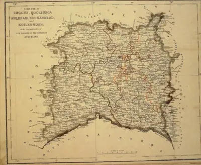 "Circars of Succur, Koolburga, Mulkhaid, Hoonanabad and Koilkondah, in the Dominions of His Highness the Nizam of Hyderabad" (map No. 5, atlas presented to the Nizam, 1865)Map · 1865
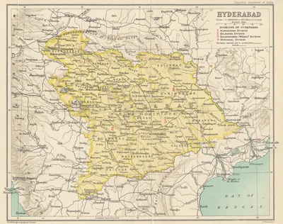 Hyderabad State (Imperial Gazetteer, 1909)Map · 1909
References
Notes (0)
Sources (4)
Spotted an error on this page? Tell us
Last updated: