పాకాల చెరువు
నర్సంపేటకు తూర్పున ఉన్న పెద్ద జలాశయం. పాకాల నదికి అడ్డంగా సుమారు ఒక మైలు పొడవైన ఆనకట్ట దీన్ని ఏర్పరిచింది. నిండినప్పుడు ఇది సుమారు 13 చదరపు మైళ్లు విస్తరిస్తుంది. 1900లో నమోదైన స్థానిక సంప్రదాయం దీన్ని ప్రతాపరుద్రుడికి, లేదా పదహారు శతాబ్దాల ముందటి 'రాజా ఖల్ద్య'కు ఆపాదించింది. కట్టపై ఉన్న శాసనాన్ని ఉదహరిస్తూ పి. వి. పరబ్రహ్మ శాస్త్రి దీన్ని కాకతీయ రాజు గణపతిదేవుడి పాలనలో ఒక మంత్రి కొడుకు జగదాళు ముమ్మడికి ఆపాదిస్తారు.
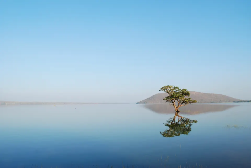
పాకాల చెరువు (పాకాల) వరంగల్కు సుమారు 50 కి.మీ. తూర్పున, పాత నర్సంపేట తాలూకాలో ఉంది.1 ఇది మున్నేరు నది పరీవాహక ప్రాంతంలో ఉంది. దాని నాలుగు వైపులా అడవి విస్తరించి ఉంది.1 “రెండు తక్కువ ఎత్తు కొండ కొమ్ముల మధ్య పాకాల నదికి అడ్డంగా 2,000 గజాల పొడవైన ఆనకట్ట వేయడం ద్వారా” ఇది ఏర్పడిందని 1909 నాటి Imperial Gazetteer (సామ్రాజ్య గెజిటీర్) వర్ణించింది.23
సరస్సు 8,000 గజాల పొడవు, 6,000 గజాల వెడల్పు ఉండేది.23 నిండినప్పుడు అది 13 చదరపు మైళ్లు విస్తరించేది.23 మున్నేరు దాని నుంచి బయటికి ప్రవహిస్తుంది.23
కట్టించినవారు: సంప్రదాయం, శాసనం
హెన్రీ కజిన్స్ (Henry Cousens) 1900 నాటి జాబితా స్థానిక సంప్రదాయాలను ఇస్తుంది.4 ఈ పెద్ద సరస్సును రాజా ప్రతాపరుద్రుడికి “ఆపాదించేవారు”.4 గ్రామానికి సుమారు నాలుగు మైళ్లు ఈశాన్యంగా గారె లేకుండా పెద్ద దిమ్మెలతో ఆయన ఒక వేసవి రాజభవనం కట్టించాడని కూడా చెప్పేవారు. దానిలో ఏమీ మిగల్లేదు.4 అయినా కట్టను 1,600 సంవత్సరాల ముందు ఒక “రాజా ఖల్ద్య” కట్టించాడని కూడా సంప్రదాయం చెప్పేది.4 కట్టపై ఉన్న ఒక రాతి స్తంభంపై కట్టించినవాడి పేరు చెప్పే శాసనం ఉందని చెప్పేవారు, కానీ కజిన్స్కు సమాచారం ఇచ్చినవాళ్లు దాన్ని చదవలేకపోయారు.4
ఆ శాసనాన్ని తర్వాత చదివారు. 1915–16లో జి. యజ్దానీ (G. Yazdani) “పాకాల, రామప్ప, ఉపరపల్లిలోని ముఖ్యమైన కాకతీయ శాసనాలను” నకలు తీసి, ఆ అచ్చులను చదవడానికి ఎల్. డి. బార్నెట్ (L. D. Barnett)కు పంపారు.5
1978లో పి. వి. పరబ్రహ్మ శాస్త్రి (P. V. Parabrahma Sastry) ఆ శాసనపు తర్వాతి ప్రచురణ ఆధారంగా రాశారు.1 కట్టపై ఉన్న శాసనం ప్రకారం, గణపతిదేవ మహారాజు కాలంలో సరస్సును కట్టారని ఆయన చెబుతారు.1 అదే శాసనం నుంచి, కట్టించినవాడు మంత్రి బయ్యన నాయకుడు, బాచమాంబల కొడుకు జగదాళు ముమ్మడి అని ఆయన పేర్కొంటారు.1 ఆ శాసనం కోసం పాకాల చెరువు శాసనం (జగదాళ ముమ్మడి) పేజీ చూడండి.
హైదరాబాద్ పురావస్తు శాఖ 1932–33 నివేదికలో “పాకాల, పాలంపేట, ఇతర చోట్ల కట్టిన పెద్ద, విశాలమైన చెరువులను” కాకతీయ వంశపు పనులలో లెక్కించింది.6
ఆనకట్ట, నీరు
పరబ్రహ్మ శాస్త్రి ఆనకట్టను ఒక మైలు పొడవైనదిగా, జేగురు రాతి గులకరాళ్లు, ఎర్ర మట్టితో కట్టినదిగా వర్ణిస్తారు.1 అది పైభాగంలో 30 నుంచి 50 అడుగుల వెడల్పు, 40 కృత్రిమ కాలువలతో ఉంది.1 దాని పరీవాహక ప్రాంతం (దానిలోకి నీరు ప్రవహించే ప్రాంతం) 80 చదరపు మైళ్లు అని ఆయన ఇస్తారు.1 అది సుమారు 17,258 ఎకరాలకు నీరు అందించగలదని, వాటిలో అప్పుడు 9,037 ఎకరాలు సాగవుతున్నాయని ఆయన చెబుతారు.1 సరస్సు ఎప్పుడూ ఎండిపోయినట్లు తెలియదు. దానిలో మొసళ్లు ఉంటాయని చెప్పేవారు.1
కట్ట మధ్యలో సితా ఖాన్ చబూత్రా అనే ఒక చిన్న మండపం శిథిలాలను కజిన్స్ గుర్తించారు.4 Imperial Gazetteer జిల్లా ముఖ్య చెరువులలో పాకాలను మొదట చేర్చింది.7
1916 చివరలో పాకాలలోని కట్టడాలను సర్వే చేయాలని యజ్దానీ ప్రణాళిక వేశారు.8 “కాకతీయ వంశపు వైభవ దినాలలో ముఖ్యమైన రాజకీయ, మత కేంద్రాలుగా” ఉన్న చోట్లలో అది ఒకటి.8
Footnotes
-
P. V. Parabrahma Sastry, The Kakatiyas of Warangal (1978), p. 205, citing the edition of the inscription in Journal of Archives, Andhra Pradesh I, pp. 61–62 (archive.org (opens in a new tab)). Cite-only; paraphrased. ↩ ↩2 ↩3 ↩4 ↩5 ↩6 ↩7 ↩8 ↩9 ↩10
-
Imperial Gazetteer of India, Provincial Series: Hyderabad State (1909), p. 162 (archive.org (opens in a new tab)). ↩ ↩2 ↩3 ↩4
-
Imperial Gazetteer: Hyderabad State (1909), p. 171 (archive.org (opens in a new tab)). ↩ ↩2 ↩3 ↩4
-
Henry Cousens, Lists of Antiquarian Remains in His Highness the Nizam’s Territories (1900), p. 49 (archive.org (opens in a new tab)). ↩ ↩2 ↩3 ↩4 ↩5 ↩6
-
G. Yazdani, Annual Report of the Archaeological Department of His Highness the Nizam’s Dominions, 1915–16 (1917), p. 10 (archive.org (opens in a new tab)). ↩
-
Annual Report of the Archaeological Department of H.E.H. the Nizam’s Dominions for the year 1342 Fasli (1932–33), bound with the report for 1931–32 (1935), p. 66 (archive.org (opens in a new tab)). ↩
-
Imperial Gazetteer: Hyderabad State (1909), p. 166 (archive.org (opens in a new tab)). ↩
-
Yazdani, Annual Report … 1915–16 (1917), p. 12 (archive.org (opens in a new tab)). ↩ ↩2
చిత్రాలు
ఆధారసూచికలు
గమనికలు (0)
ఆధారాలు (5)
ఈ పేజీలో పొరపాటు కనిపించిందా? మాకు తెలియజేయండి
చివరి సవరణ: