Pakhal
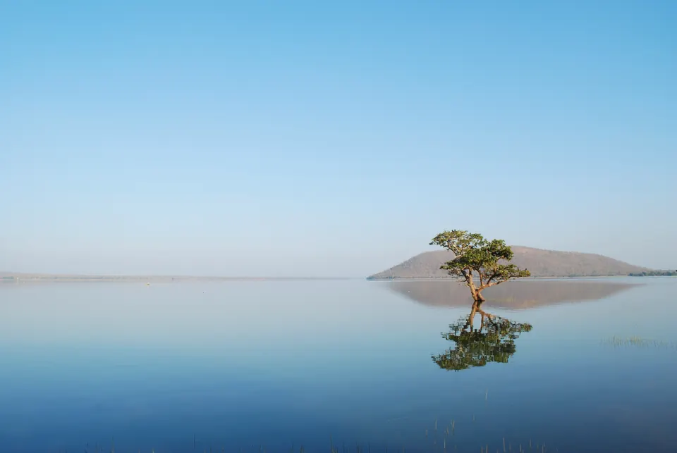
The Pakhal lake east of Warangal, the largest Kakatiya irrigation tank. Jagadala Mummadi built it in Ganapatideva's reign, and his pillar inscription stands on its bund (embankment).
The lake
The Pakhal lake lies about 50 km east of Warangal, in the old Narsampet taluk, and densely wooded hills enclose it on the north, south and east.12 The Imperial Gazetteer of 1909 called it the largest artificial sheet of water in Hyderabad State.1
According to the gazetteer, the lake was formed by a dam more than 2,000 yards long across the Pakhal river, where the river cuts between two low hills.13 The lake covered nearly 13 square miles.13
The gazetteer noted channels carrying water away for irrigation, and a depth of 30 to 40 feet.4 At the centre of the dam it noted the ruins of a small pavilion called the chabutra of Shitab Khan.4 It also noted that the lake was full of fish, otters and crocodiles.4
P. V. Parabrahma Sastry describes the dam as about a mile long, built of laterite gravel and red earth, with 40 channels.2
The builder
A Sanskrit inscription on a pillar on the bund (embankment) records who built the tank.56 Jagadala Mummadi built it in the reign of Ganapatideva.56 He was a son of the king’s chief minister Bayyana-nayaka.56
He built the tank at a holy place called the Maudgalya-tirtha, near a temple of Shiva-Ramanatha, and founded a town called Ganapapura beside it.56 See the Pakhal lake inscription.
Survey
G. Yazdani of the Nizam’s Archaeological Department copied the inscription in the 1915–16 season.7 He planned to survey “the old monuments at Pakhal, Palampet, Borlapalli and Uparpalli”.8 He described these places as political and religious centres of the Kakatiya dynasty.8 His photographs of the lake and of the inscribed pillar are listed in the report for that year.9
Footnotes
-
Imperial Gazetteer of India: Hyderabad State (1909), p. 90 (archive.org (opens in a new tab)). ↩ ↩2 ↩3 ↩4
-
P. V. Parabrahma Sastry, The Kakatiyas of Warangal (1978), p. 205. ↩ ↩2
-
Imperial Gazetteer of India, Provincial Series: Hyderabad State (1909), p. 4 (archive.org (opens in a new tab)). ↩ ↩2
-
Imperial Gazetteer of India: Hyderabad State (1909), p. 91 (archive.org (opens in a new tab)). ↩ ↩2 ↩3
-
P. Sreenivasachar (ed.), A Corpus of Inscriptions in the Telingana Districts of Andhra Pradesh, Part III (1956), p. 150, No. Wg. 15 (archive.org (opens in a new tab)). Paraphrased. ↩ ↩2 ↩3 ↩4
-
L. D. Barnett (1919), reprinted in Gajjala Vasanta Lakshmi (ed.), Epigraphia Telanganica, vol. 2 (2023), p. 235, No. 201. Paraphrased. ↩ ↩2 ↩3 ↩4
-
Annual Report of the Archaeological Department of His Highness the Nizam’s Dominions, 1915-16 (1917), p. 10 (archive.org (opens in a new tab)). ↩
-
Annual Report of the Archaeological Department … 1915-16 (1917), p. 12 (archive.org (opens in a new tab)). ↩ ↩2
-
Annual Report of the Archaeological Department … 1915-16 (1917), p. 26 (archive.org (opens in a new tab)). ↩
Photos
Related
People
Monuments
Inscriptions
References
Notes (0)
Sources (5)
Spotted an error on this page? Tell us
Last updated: