Hayathnagar
Village about nine miles east of Hyderabad on the old road to Masulipatam. Hayat Bakhsh Begum, mother of Abdullah Qutb Shah, founded it in AH 1035 (1625–26) as Hayatabad. Its great Qutb Shahi mosque stands inside a walled caravanserai (travellers' inn) of several hundred rooms. Tavernier's 'Jatenagar', the first stage on his road from Golconda to the Kollur diamond mine, has been identified with it.
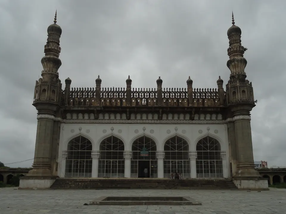
Hayathnagar lies about nine miles east of Hyderabad. In 1927 Syed Ali Asgar Bilgrami wrote that Hayat Bakhsh Begum, called Hayat Ma, the mother of Abdullah Qutb Shah, “built this village, in 1035 A.H, by the name of Hayatabad”.1 He added that a Qutb Shahi milestone pillar of masonry still stood between the sixth and seventh miles of the road from the city.1
She was the daughter of Muhammad Quli Qutb Shah and the wife of Sultan Muhammad.2 Bilgrami calls the village “a favourite resort of the Begam”.2 According to him, her infant son Abdullah’s first shaving was celebrated in the royal palaces of the village, with festivities lasting twelve days.13 See the Qutb Shahis.
The caravanserai
Its chief monument is a great Qutb Shahi mosque.34 It stands inside a walled caravanserai (travellers’ inn) about 450 by 400 feet.34 Around it are “several hundred double rooms of massive masonry which were intended for the use of travellers”.34 It had gates on three sides, a royal garden, and a great well once worked by elephants.34
In 1927 the caravanserai and the mosque were “entirely uninhabited”, and they stood a little apart from the village.34 See the Hayat Bakhshi Mosque, Hayathnagar. Bilgrami explained the local name of the Ma Saheba tank near Golconda by the same queen’s by-name, “Ma Saheba”.5
On the road to the coast
The caravanserai stood on the road east from the capital. Jean-Baptiste Tavernier described his usual route from Golconda to Machilipatnam (then Masulipatam) by way of the diamond mine at Kollur.67 He gives the first stage as Golconda to Tenara, 4 coss (a measure of distance), where a fine house and garden were reserved for the queen.67 The next was “From Tenara to Jatenagar”, 12 coss.67 His editor V. Ball identified Jatenagar as Hayatnagar.67
The road then ran on through Patengy, Pengeul and Nagelpar to Kollur, Vijayawada (then Bezwada) and Machilipatnam.78 Ball identified those three places as Puntangi, Pungul and Nagulpad.78 See Machilipatnam and the map of the Qutb Shahi kingdom.
Footnotes
-
Bilgrami, Landmarks of the Deccan (1927), p. 55 (archive.org (opens in a new tab)). ↩ ↩2 ↩3
-
Bilgrami, Landmarks of the Deccan (1927), p. 169 (archive.org (opens in a new tab)). ↩ ↩2
-
Bilgrami, Landmarks of the Deccan (1927), p. 56 (archive.org (opens in a new tab)). ↩ ↩2 ↩3 ↩4 ↩5 ↩6
-
Bilgrami, Landmarks of the Deccan (1927), p. 57 (archive.org (opens in a new tab)). ↩ ↩2 ↩3 ↩4 ↩5
-
Syed Ali Asgar Bilgrami, Landmarks of the Deccan (1927), p. 52 (archive.org (opens in a new tab)). ↩
-
Jean-Baptiste Tavernier, tr. V. Ball, Travels in India, Vol. I (1889), p. 172 (archive.org (opens in a new tab)). ↩ ↩2 ↩3 ↩4
-
Tavernier, Travels in India, Vol. I (1889), p. 173 (archive.org (opens in a new tab)). ↩ ↩2 ↩3 ↩4 ↩5 ↩6
-
Tavernier, Travels in India, Vol. I (1889), p. 174 (archive.org (opens in a new tab)). ↩ ↩2
Photos
Related
Monuments
References
Notes (0)
Sources (2)
Spotted an error on this page? Tell us
Last updated: