Gurramkonda
Hill fort in the uplands of the old Cuddapah district (later Chittoor), the seat of a Muslim governorship from Golconda times. The Nawab of Cuddapah ceded it to the Marathas, apparently after his defeat by Balwant Rao in 1757. In 1767 the Maratha Peshwa gave it to Haidar Ali's brother-in-law Mir Sahib, who handed it to Haidar. The Marathas took it back by siege in 1771 and kept it by the treaty of 1772, and Tipu recovered it in 1773–74. It held out against the Nizam's army for a year in 1791–92, and passed to the Nizam by the treaty of 1792.
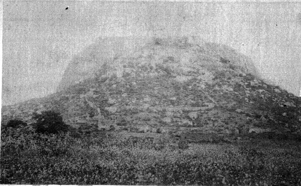
Gurramkonda is a fortified hill in the upland part of the old Kadapa (then Cuddapah) country, above the Eastern Ghats. In the eighteenth century its fort passed back and forth between the Nawabs of Kadapa, the Marathas, Mysore and the Nizam.123
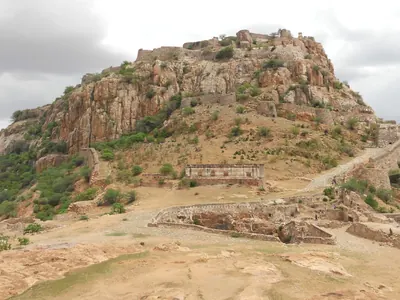
Gribble’s Kadapa manual of 1875 describes the fort as “built on the top of a hill, some 500 feet high, protected on three sides by an almost perpendicular precipice” (a sheer cliff).4 On the fourth side it had ramparts and redoubts (small outworks), and a wall joined the upper fort to the lower.4 The same book prints a photograph of “Gurramkonda Hill and Fort”.5 See the Marathas in the Telugu country.
The fort and its governors
Gribble thought that the Muslim rulers built the fort soon after the fall of Vijayanagara.6 In his view, they built it to keep the poligars (local chiefs) of the uplands in check.6 He admitted that this was “a bold conjecture” (guess) “on my part, for no date can be found which fixes its building”.6 He found nothing of Hindu architecture in it.6
Its governors, he says, held it on military tenure (in return for military service), with “the right of coining money”.7 Gurramkonda rupees were still in use at the end of the eighteenth century.7 Walter Elliot lists Gurramkonda pagodas among the gold coins in use in the Ceded Districts when the British took them over.8
The Kurnool manual tells how a Golconda general campaigned against the chiefs of the south.9 He pursued their forces “to the fort of Gurramkonda, which surrendered”.9 Wilks says that the Qutb Shahi court granted the fort and district as a jagir (land grant) to the grandfather of Mir Ali Raza Khan (Mir Sahib).1 He adds that the Pathan Nawab of Kadapa later drove the family out.1
Grant Duff lists Gurramkonda among the districts of the Hyderabad Karnatak after the fall of Golconda in 1687.10 In 1690 the Mughal general Zulfiqar Khan marched by way of “Kadapa, and Garamkonda” into the Karnatak plain.1011
Gribble records a story told in the district about the fort’s name, which he takes to mean “horse hill”.1213 In the story, a horse kept on the summit guarded the fort.1213 Then “a Mahratta thief” climbed the rock by driving iron nails into it, and carried the horse down.1213 He was caught, and his hands were cut off.1213 But “the spell, however, had been broken”, and “when next the fort was attacked, it was taken”.1213
Between the Marathas and Mysore
The Kadapa gazetteer of 1915 says that Balwant Rao defeated the Nawab of Kadapa near Kadapa in 1757.14 It adds: “it was apparently on this occasion that the Mahrattas were bought off” (paid to leave) “by the cession of Gurramkonda”.14 Wilks too says that the Nawab “purchased the retreat of a Mahratta invasion by the cession of Goorumconda”.1
In 1767 the Peshwa Madhavrao I took Sira.115 Its commander was Haidar Ali’s brother-in-law, Mir Sahib.115 Mir Sahib received from the Marathas “the fort and district of Goorumconda” in exchange.115 Gribble says that Haidar’s wife persuaded her brother to make up for one betrayal by a second.15 He says that Mir Sahib then handed Gurramkonda to Haidar as Haidar marched on it.15 The Kadapa gazetteer dates Haidar’s possession of the fort to 1766.14
In 1771 Madhavrao’s uncle Trimbak Rao besieged Gurramkonda, which Mir Sahib’s nephew Sayyid Sahib held.216 It “sustained a siege of two months, and then capitulated” (surrendered).216 Morari Rao of Gooty guaranteed the terms.216
Gribble calls this “the only occasion when we read of the Gurramkonda fort being conquered by a siege; it was often yielded voluntarily”.15 He suspected treachery.15 The treaty of 1772 left Gurramkonda with the Marathas.17181920 But Tipu won it back for his father between September 1773 and February 1774.17181920
Haidar made Mir Sahib governor of Gurramkonda.212223 From there Mir Sahib ruled the upland part of the Kadapa country.212223 He died in 1781 and was buried in a mosque at the foot of the fort.212223 See Madhavrao I and Balwant Rao Mendle.
The siege of 1791–1792
In the third war against Tipu, the Nizam’s army began its siege of Gurramkonda on 15 September 1791.43 Its guns made no impression on the lower fort.43 Then Captain Read’s British battery made a breach in it in two days.43 The lower fort was stormed on the night of 7 November.43
Tipu’s son Fateh Haidar then surprised the besiegers.43 He captured their commander Hafizji and relieved (rescued) the garrison.43 But the Nizam’s army returned.43 The upper fort held out “until the treaty of 1792, by which Tippoo ceded Gurramkonda, together with the whole of his Cuddapah possessions, to the Nizam”.43
Gribble noted that there was no water in either the upper or the lower fort, except a small rock-cut tank.3 From the Nizam, the Kadapa country passed with the other Ceded Districts to the East India Company in 1800.24 See Adoni and the Asaf Jahis.
Footnotes
-
Mark Wilks, Historical Sketches of the South of India, Vol. II (1817), p. 11 and note (archive.org (opens in a new tab)). ↩ ↩2 ↩3 ↩4 ↩5 ↩6 ↩7
-
Wilks, Historical Sketches, Vol. II (1817), p. 137 (archive.org (opens in a new tab)). ↩ ↩2 ↩3 ↩4
-
Gribble, Cuddapah (1875), p. 102 (archive.org (opens in a new tab)). ↩ ↩2 ↩3 ↩4 ↩5 ↩6 ↩7 ↩8 ↩9 ↩10
-
Gribble, Cuddapah (1875), p. 101 (archive.org (opens in a new tab)). ↩ ↩2 ↩3 ↩4 ↩5 ↩6 ↩7 ↩8 ↩9 ↩10
-
Gribble, Cuddapah (1875), plate “Gurramkonda Hill and Fort”, between pp. 90 and 91 (archive.org (opens in a new tab)). ↩
-
J. D. B. Gribble, A Manual of the District of Cuddapah (1875), pp. 88–89 (archive.org (opens in a new tab)). ↩ ↩2 ↩3 ↩4
-
Gribble, Cuddapah (1875), p. 89 (archive.org (opens in a new tab)). ↩ ↩2
-
Walter Elliot, Coins of Southern India (1886), p. 145 (archive.org (opens in a new tab)). ↩
-
Narahari Gopalakristnamah Chetty, A Manual of the Kurnool District (1886), p. 27 (archive.org (opens in a new tab)). ↩ ↩2
-
James Grant Duff, A History of the Mahrattas, Vol. I (1826), p. 346 (archive.org (opens in a new tab)). ↩ ↩2
-
Jadunath Sarkar, History of Aurangzib, Vol. V (1924), p. 68 (archive.org (opens in a new tab)). ↩
-
Gribble, Cuddapah (1875), p. 91 (archive.org (opens in a new tab)). ↩ ↩2 ↩3 ↩4 ↩5
-
Gribble, Cuddapah (1875), p. 92 (archive.org (opens in a new tab)). ↩ ↩2 ↩3 ↩4 ↩5
-
Brackenbury, Cuddapah (1915), p. 44 (archive.org (opens in a new tab)). ↩ ↩2 ↩3
-
Gribble, Cuddapah (1875), p. 96 (archive.org (opens in a new tab)). ↩ ↩2 ↩3 ↩4 ↩5 ↩6 ↩7
-
Wilks, Historical Sketches, Vol. II (1817), p. 138 (archive.org (opens in a new tab)). ↩ ↩2 ↩3
-
Grant Duff, History of the Mahrattas, Vol. II (1826), p. 217 (archive.org (opens in a new tab)). ↩ ↩2
-
Wilks, Historical Sketches, Vol. II (1817), p. 151 (archive.org (opens in a new tab)). ↩ ↩2
-
Wilks, Historical Sketches, Vol. II (1817), p. 159 (archive.org (opens in a new tab)). ↩ ↩2
-
Grant Duff, History of the Mahrattas, Vol. II (1826), p. 268 (archive.org (opens in a new tab)). ↩ ↩2
-
C. F. Brackenbury, Madras District Gazetteers: Cuddapah, Vol. I (1915), p. 40 (archive.org (opens in a new tab)). ↩ ↩2 ↩3
-
Gribble, Cuddapah (1875), p. 98 (archive.org (opens in a new tab)). ↩ ↩2 ↩3
-
Gribble, Cuddapah (1875), p. 99 (archive.org (opens in a new tab)). ↩ ↩2 ↩3
-
W. Francis, Madras District Gazetteers: Anantapur (1905), p. 23 (archive.org (opens in a new tab)). ↩
Photos
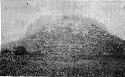 "Gurramkonda Hill and Fort": photograph in Gribble's Manual of the District of Cuddapah (1875), plate between pp. 90 and 91Historic photograph · 1875
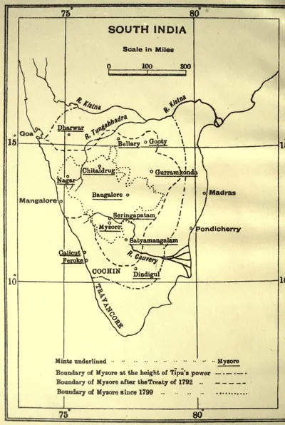 "Mints of Haidar Ali and Tipu Sultan": map with the boundaries of Mysore at the height of Tipu's power, after 1792 and after 1799 (Henderson 1921, frontispiece)Map · 1921
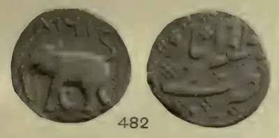 Copper paisa of Tipu Sultan from the Zafarabad (Gurramkonda) mint, dated 1218 (Henderson 1921, pl. IX, No. 482)Coin · 1921
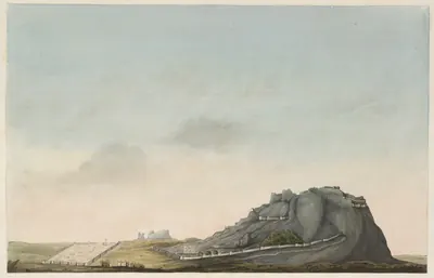 Gurramkonda fort: painting by Thomas Fraser, dated 15 February 1800 (British Library)Drawing · 1800
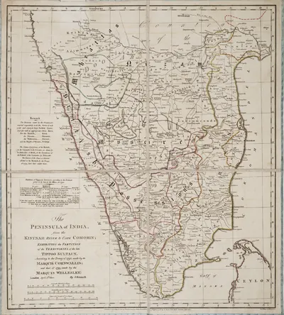 James Rennell, "The Peninsula of India ... exhibiting the partition of the territories of the late Tippoo Sultaun, according to the treaty of 1792 ... and that of 1799" (London, 1800), Royal Museums Greenwich K1047Map · 1800
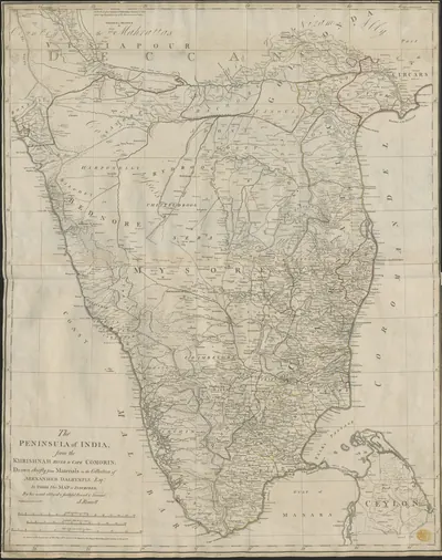 James Rennell, "The Peninsula of India, from the Khrishnah River to Cape Comorin" (London, 1788), British Library Maps K.Top.115.65.1: the Mahrattas, Visiapour, Adoni, Gooty, Golconda and the CircarsMap · 1788
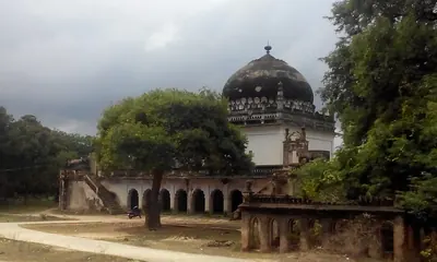 The domed tomb at Gurramkonda named on Commons as the maqbara of Mir Raza Ali (2016); Gribble says Mir Sahib was buried in a mosque at the foot of the fortPhotograph · 2016
Related
People
Abdul Nabi Khan (Nawab of Cuddapah)
c. 1714 CE
Pathan (Miana) Nawab of Cuddapah in the early eighteenth century. Gribble's chronology calls him 'the greatest of the Cuddapah Nabobs'. Kirmani says that the emperor Bahadur Shah gave him Cuddapah as a land grant, and the Cuddapah gazetteer dates his governorship from 1714. He took Sidhout from its fort commander in 1714 and held Gandikota, Cumbum and Gurramkonda. He made the poligar of Punganur pay him tribute, raided the Baramahal and joined the Nawab of Arcot in taking money from Mysore. Local tradition says he founded the town of Cuddapah. He had stopped ruling by 1732, when an inscription names his son as Nawab.
Haidar Ali
1761–1782 CE
A soldier who made himself master of Mysore in 1761 and ruled it until he died in December 1782. In the Telugu country he took Penukonda and Madakasira from the Maratha Morari Rao in 1762. He won back Gurramkonda through his brother-in-law Mir Sahib in 1768, took Bellary in 1775 and took Gooty from Morari Rao in 1776. In 1779 he conquered the Nawab of Cuddapah, and the Nawab of Kurnool and the poligars of the Bellary and Anantapur country paid him tribute. His invasion of the Carnatic in 1780 began the Second Mysore War.
Madhavrao I
1761–1772 CE
Peshwa (chief minister) of the Marathas from 1761 to his death in November 1772, and the son of Balaji Baji Rao. As a young man he fought beside his uncle Raghunath Rao against Nizam Ali at Rakshasbhuvan on the Godavari in 1763. In his wars with Haidar Ali of Mysore he took Sira in 1767, and the Mysore commander Mir Sahib then received Gurramkonda from the Marathas. His uncle Trimbak Rao took Gurramkonda by siege in 1771. The treaty of June 1772 left it with the Marathas until Tipu took it back in 1773–74.
Qamar-ud-din Khan
1781–1799 CE
Son of Mir Sahib and cousin of Tipu Sultan. He followed his father in command of the Gurramkonda and Cuddapah country in 1781–82. In 1783 he defeated a claimant to the Nawabship of Cuddapah and the English force that had taken Cumbum. Tipu arrested him in 1785 and took away his jagirs, but he led Mysore troops again in 1791. After the fall of Seringapatam in 1799 he surrendered to the British. The partition treaty bound the Nizam to give him a personal jagir in the Gurramkonda districts.
Tipu Sultan
1782–1799 CE
Son of Haidar Ali and ruler of Mysore from December 1782 until he was killed at the fall of Seringapatam on 4 May 1799. As a young commander he took Gurramkonda back from the Marathas in 1773–74. As Sultan he held Gooty, Gurramkonda, Cuddapah, Bellary and the Anantapur country. He gave Gooty and Gurramkonda the new names Faiz Hisar and Zafarabad and struck copper coins at both. He besieged Adoni in 1786 and seized the poligars of Rayadurg and Harpanahalli. By the treaty of 1792 he gave up Cuddapah, Gurramkonda, Bellary and Tadpatri to the Nizam. The rest of his Telugu districts went to the Nizam after his death and were ceded to the East India Company in 1800.
Balwant Rao Mendle
before 1760 CE
Maratha commander of the Peshwa Balaji Baji Rao, left in the Carnatic in 1757 to collect tribute. On 24 September 1757 he defeated the Nawabs of Cuddapah and Kurnool near Cuddapah. The Nawab of Cuddapah was killed, and the Marathas took Gurramkonda and Punganur. He then marched across the Cuddapah country to the coast. He took tribute from the zamindars of Venkatagiri and Kalahasti and was bought off before Nellore. He was killed at Panipat in December 1760.
Mir Ali Raza Khan (Mir Sahib)
before 1781 CE
Brother-in-law of Haidar Ali and governor of Gurramkonda, who died in 1781. His family had held Gurramkonda as a jagir (land grant) under Golconda until the Nawabs of Cuddapah took it from them. As Haidar's commander at Sira, he surrendered the fort to the Marathas in 1767 and received Gurramkonda from them. He came back to Haidar's side in 1768 and held Gurramkonda for him. In 1779 he led the first attack on the Nawab of Cuddapah. Haidar gave him the conquered country, with Gurramkonda, as a military grant, for which he had to keep 3,000 horse. He was buried in a mosque at the foot of Gurramkonda fort.
Raghunath Rao
Maratha general and statesman, called Raghoba. He was the brother of the Peshwa Balaji Baji Rao and, from 1761, regent for his nephew Madhavrao I. In 1763, after Nizam Ali had plundered Poona, he marched on Hyderabad. The city wall kept him out, but he took a payment from the suburbs. He then routed the Nizam's army on the Godavari at Rakshasbhuvan. He held the Peshwaship briefly in 1773–74, when Haidar Ali took Sira and Gurramkonda from the Marathas.
References
Notes (0)
Sources (9)
Spotted an error on this page? Tell us
Last updated: