Gooty
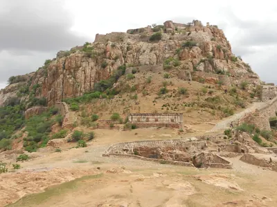
Town inside a ring of rocky hills in the Anantapur district, crowned by the hill fortress of Gutti, 2,105 feet above the sea. Western Chalukya records of 1121–23 are cut on its summit rock, beside a Sanskrit verse in praise of king Bukka of Vijayanagara. Vijayanagara held it as the head of a province until after 1565, and it later fell to Golconda and to the Maratha Morari Rao. Haidar Ali took it in 1776 (1775 in the Anantapur gazetteer). Tipu Sultan named it Faiz Hisar and struck copper coins there. After his death it went to the Nizam in 1799, and to the Company with the Ceded Districts in 1800.
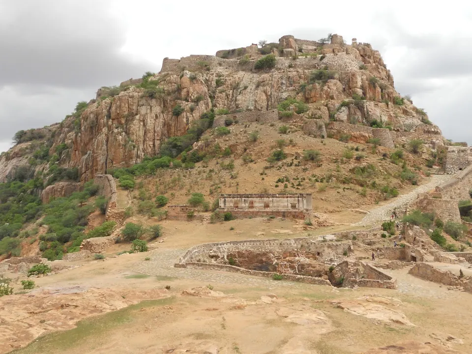
The Anantapur gazetteer of 1905 called Gooty “a fairly flourishing place but is neither a commercial nor industrial centre”.12 It added that “the centre of the place is its famous old hill-fortress”.12 A rough ring of steep, bare, rocky hills, joined to each other by lower spurs, encloses a large area of level ground.12 “Within this enclosure is the original town of Gooty.”12
The westernmost hill is a precipitous mass of bare rock, and it carries the citadel.2 A paved path leads up to it.2 Walls “perched one above the other along its precipitous sides” defend it.2 In Wilks’s words they form “a citadel which famine or treachery can alone reduce”.2 See the Gooty fort.
History to Vijayanagara
The gazetteer found that “materials for a continuous history of the fort are not available”.34 Local tradition derives the name from the sage Gautama.34 The Ganga king Marasimha II (973) styled himself “King Ganga of Gutti”.34
Near the top of the citadel, by a deserted Narasimha temple, are eight inscriptions.34 Three are of the Western Chalukya king Vikramaditya VI, and two of these are dated in 1121–22 and 1122–23.34 They show “that the fort was a place of importance 880 years ago”.34 The Hoysala Vira Ballala II claimed to have taken Gooty, and an officer of the Yadava king Singhana subdued “the Pandyas of Gooty”.34
The eighth inscription is a Sanskrit verse in praise of the rock as the nave (hub) of the wheel of “the illustrious king Bukka”.5 E. Hultzsch identified this Bukka with Bukka I of Vijayanagara.5
Robert Sewell’s lists of 1882 recorded the local belief that the fort was built by Krishnadeva Raya.64 They took the Bukka of the verse for one of his officers.64 The gazetteer answered that the fortifications “had been begun many years before his time”.64
Under Vijayanagara, inscriptions at Tadpatri show that Gooty “was the capital of a rajya (or province)”.4 Grants of Sadasiva of 1548 and of Venkatapati of 1603 name “Gutti valita” (the Gooty division).7 They also name the god Raghunayaka “on the hill-fort of Gutti”.7 See the Gooty inscription and Bukka I.
After 1565
The gazetteer says that Muslim armies did not take the place until some time after 1565.48 It adds that “as late as the end of the sixteenth century it was still part of the possessions of the fallen Vijayanagar princes who ruled from Penukonda”.48
A Mackenzie manuscript says that Gooty fell by treachery to Mir Jumla after a twelve-years’ siege.8 This Mir Jumla was perhaps the minister of Abdullah Qutb Shah of Golconda.8 The gazetteer dismissed the story: “It seems an unlikely story.”8 The big tank west of the town is said to have been built in 1619 by “Rama Raya, one of the expatriated princes of the Vijayanagar dynasty”.3
About 1746 the Maratha Morari Rao established himself in the fort.86 Haidar Ali took it from him after a long siege in 1776, and it passed to the Company in 1799.86
Wilks says that a Maratha of the same Ghorpade family, Siddoji, was already “establishing a Mahratta power at Gooti” about 1713.910 In 1744 Morari Rao gave up Tiruchirappalli (then Trichinopoly) to the first Nizam.910 According to Wilks, Morari Rao then “had obtained his recognition of the state of Gooti as a dependency of the Soubadars of the Deckan”.910 See Morari Rao of Gooty.
The body of Sir Thomas Munro rested for a time in the cemetery at the foot of the citadel path.11 See Penukonda.
Haidar Ali and Tipu Sultan
Haidar Ali first came to Gooty in 1769.12 Wilks says that he “was not yet prepared to execute his intentions” against Morari Rao.12 The two rivals met and exchanged costly presents.12
In 1776, after taking Bellary, Haidar demanded a contribution.13 Morari Rao answered that “he also was a Cena putti (General), and was in the habit of levying, not paying contributions”.13 Haidar then besieged the fort.13
The town and lower forts were stormed after about five weeks.141516 The citadel surrendered early in April, because its garrison was dying of thirst.141516 Morari Rao was sent prisoner to Kabbaldurga, where he soon died.141516 The Anantapur gazetteer quotes Wilks’s account at length, but it dates the capture to 1775.171819
In 1782 the Company’s Resident at Tanjore drew up terms for restoring the old Mysore house.2021 In them the Company reserved the right to reinstate “the family of Morarow in the country of Gooty”.2021 The Rani’s agent replied that “Gooty is not to be delivered to its former possessor”.2021 See Mysore under Haidar Ali and Tipu Sultan.
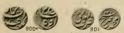
For his war with the Marathas and the Nizam in 1776, Haidar made Gooty the depot and meeting place of his army and of his tributaries’ contingents.22 He struck a gold “new Muhammad Shahi” pagoda (coin) there.2324 It was a copy of an older Mughal pagoda of the same mint, which Morari Rao had also issued.2324
Tipu Sultan renamed the town.25 Kirkpatrick wrote that he gave “to Gooty, that of Fyze-Hisar”.25 One of Tipu’s letters of December 1785 is addressed to his postmaster at “Fyze Hisar (Gooty)”.26 Faiz Hisar, “The Fort of Bounty”, was one of Tipu’s mints, and it issued an extensive series of copper coins.27
In 1786 Tipu stored the guns of Adoni at Gooty and Bellary.28 In 1795 he gathered troops there “on the pretence of demanding tribute from Kurnool”.29
The Nizam and the Company
“Haidar, and after him his son Tipu, held the place until 1799.”19 In the partition treaty of that year, “Fyse Hussur Kubal”, the town of Faiz Hisar, heads the list of districts given to the Nizam.30
Colonel Bowser was sent to take over the fort for the Nizam.19 He found it held by a Brahmin convert named Zeruwar Khan.19 Zeruwar Khan had imprisoned Tipu’s killadar (fort commander) and offered the place to the Marathas.19 Bowser’s two siege guns from Banganapalle had nearly made a breach when the garrison put Zeruwar Khan in irons.19 They surrendered on 3 August 1799.19
“Gooty formed part of the territory ceded to the Company by the Nizam in 1800.”19 See the Gooty fort.
Footnotes
-
W. Francis, Madras District Gazetteers: Anantapur (1905), p. 152 (archive.org (opens in a new tab)). ↩ ↩2 ↩3 ↩4
-
Francis, Anantapur Gazetteer (1905), p. 153 (archive.org (opens in a new tab)). ↩ ↩2 ↩3 ↩4 ↩5 ↩6 ↩7 ↩8
-
Francis, Anantapur Gazetteer (1905), p. 155 (archive.org (opens in a new tab)). ↩ ↩2 ↩3 ↩4 ↩5 ↩6 ↩7 ↩8
-
Francis, Anantapur Gazetteer (1905), p. 156 (archive.org (opens in a new tab)). ↩ ↩2 ↩3 ↩4 ↩5 ↩6 ↩7 ↩8 ↩9 ↩10 ↩11 ↩12 ↩13
-
E. Hultzsch, South-Indian Inscriptions, Vol. I (1890), p. 167, No. 154 (archive.org (opens in a new tab)). ↩ ↩2
-
Robert Sewell, Lists of the Antiquarian Remains in the Presidency of Madras, Vol. I (1882), p. 115 (archive.org (opens in a new tab)). ↩ ↩2 ↩3 ↩4 ↩5
-
V. Rangacharya, A Topographical List of the Inscriptions of the Madras Presidency, Vol. I (1919), p. 5, Anantapur Nos. 28 and 33 (archive.org (opens in a new tab)). ↩ ↩2
-
Francis, Anantapur Gazetteer (1905), p. 157 (archive.org (opens in a new tab)). ↩ ↩2 ↩3 ↩4 ↩5 ↩6 ↩7
-
Mark Wilks, Historical Sketches of the South of India, Vol. I (1810), p. 226 (archive.org (opens in a new tab)). ↩ ↩2 ↩3
-
Wilks, Historical Sketches, Vol. I (1810), p. 381 (archive.org (opens in a new tab)). ↩ ↩2 ↩3
-
Francis, Anantapur Gazetteer (1905), p. 154 (archive.org (opens in a new tab)). ↩
-
Mark Wilks, Historical Sketches of the South of India, Vol. II (1817), p. 131 (archive.org (opens in a new tab)). ↩ ↩2 ↩3
-
Wilks, Historical Sketches, Vol. II (1817), p. 167 (archive.org (opens in a new tab)). ↩ ↩2 ↩3
-
Wilks, Historical Sketches, Vol. II (1817), p. 168 (archive.org (opens in a new tab)). ↩ ↩2 ↩3
-
Wilks, Historical Sketches, Vol. II (1817), p. 170 (archive.org (opens in a new tab)). ↩ ↩2 ↩3
-
Wilks, Historical Sketches, Vol. II (1817), p. 171 (archive.org (opens in a new tab)). ↩ ↩2 ↩3
-
Francis, Anantapur Gazetteer (1905), p. 158, quoting Wilks (archive.org (opens in a new tab)). ↩
-
Francis, Anantapur Gazetteer (1905), p. 159, quoting Wilks (archive.org (opens in a new tab)). ↩
-
Francis, Anantapur Gazetteer (1905), p. 160 (archive.org (opens in a new tab)). ↩ ↩2 ↩3 ↩4 ↩5 ↩6 ↩7 ↩8
-
Aitchison, Treaties, Vol. IX (1909), p. 205 (archive.org (opens in a new tab)). ↩ ↩2 ↩3
-
Aitchison, Treaties, Vol. IX (1909), p. 206 (archive.org (opens in a new tab)). ↩ ↩2 ↩3
-
Wilks, Historical Sketches, Vol. II (1817), p. 180 (archive.org (opens in a new tab)). ↩
-
J. R. Henderson, The Coins of Haidar Ali and Tipu Sultan (Madras Government Museum, 1921), p. 1 (archive.org (opens in a new tab)). ↩ ↩2
-
Henderson, Coins of Haidar Ali and Tipu Sultan (1921), p. 77 (archive.org (opens in a new tab)). ↩ ↩2
-
William Kirkpatrick (tr.), Select Letters of Tippoo Sultan (1811), preface, p. xxx (archive.org (opens in a new tab)). ↩ ↩2
-
Kirkpatrick, Select Letters of Tippoo Sultan (1811), p. 226, Letter CXCII (archive.org (opens in a new tab)). ↩
-
Henderson, Coins of Haidar Ali and Tipu Sultan (1921), p. 76 (archive.org (opens in a new tab)). ↩
-
Wilks, Historical Sketches, Vol. II (1817), p. 549 (archive.org (opens in a new tab)). ↩
-
Mark Wilks, Historical Sketches of the South of India, Vol. III (1817), p. 324 (archive.org (opens in a new tab)). ↩
-
C. U. Aitchison, A Collection of Treaties, Engagements and Sanads, Vol. IX (4th ed., 1909), p. 63, partition treaty of Mysore, Schedule B (archive.org (opens in a new tab)). ↩
Photos
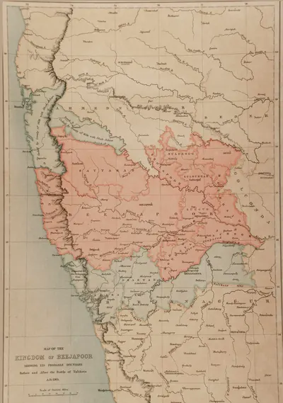 "Map of the Kingdom of Beejapoor, shewing its probable boundary before and after the Battle of Talikota, A.D. 1565" (Taylor and Fergusson, Architecture at Beejapoor, 1866, facing p. 1)Map · 1866
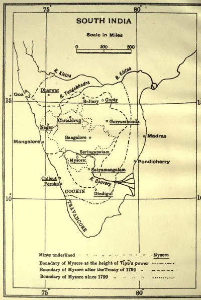 "Mints of Haidar Ali and Tipu Sultan": map with the boundaries of Mysore at the height of Tipu's power, after 1792 and after 1799 (Henderson 1921, frontispiece)Map · 1921
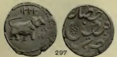 Copper paisa of Tipu Sultan from the Faiz Hisar (Gooty) mint, dated 1222 (Henderson 1921, pl. VI, No. 297)Coin · 1921
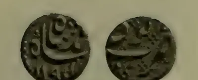 Gold "new Muhammad Shahi" pagoda of Haidar Ali struck at Gooty, dated 1194 (Henderson 1921, pl. I, No. 3)Coin · 1921
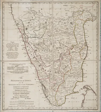 James Rennell, "The Peninsula of India ... exhibiting the partition of the territories of the late Tippoo Sultaun, according to the treaty of 1792 ... and that of 1799" (London, 1800), Royal Museums Greenwich K1047Map · 1800
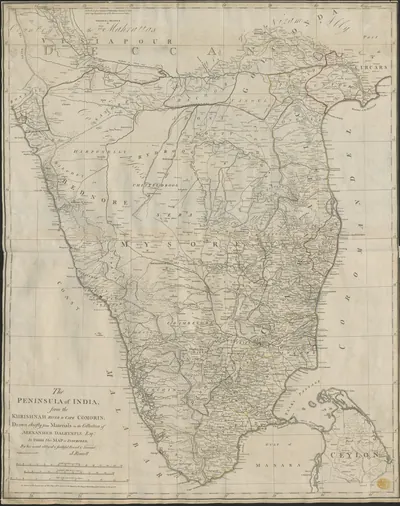 James Rennell, "The Peninsula of India, from the Khrishnah River to Cape Comorin" (London, 1788), British Library Maps K.Top.115.65.1: the Mahrattas, Visiapour, Adoni, Gooty, Golconda and the CircarsMap · 1788
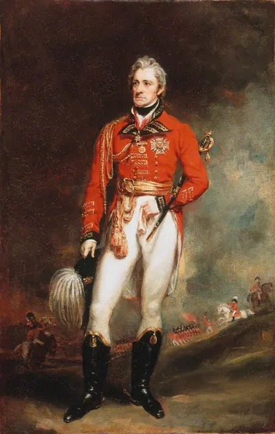 Major-General Sir Thomas Munro, later Governor of Madras, in general officer's uniform: portrait by Martin Archer Shee, 1819 (National Army Museum)Other · 1819
 Small gold coins of Farrukhsiyar from the Deccan mints of Imtiyazgarh (Adoni), regnal year 3, and Guti (Gooty), AH 1128 (Lane-Poole 1892, Nos. 900a and 901, pl. XXII)Coin · 1892
 The Gooty fort on its rock (2013)Photograph · 2013
Related
Dynasties
People
Ballala II (Hoysala)
1173–1220 CE
Hoysala king, crowned at Dorasamudra on 22 July 1173, who defeated the Seuna army at Soratur, took the Pandya fortress of Uchchangi and pushed his frontier to the Bhima river. He took Nolambavadi: his records in the Anantapur country are at Parigi (Saka 1100, 1178) and Hemavati (1205–06), and an inscription at Harihar claims that he took Gooty. B. Lewis Rice dates his reign 1173–1220.
Morari Rao Ghorpade
c. 1741–1776 CE
A Maratha soldier who fought for pay, of the Ghorpade family. He was lord of Gooty from the 1740s until Haidar Ali took the fortress in 1776. The Marathas left him as governor of Trichinopoly in 1741. He gave it up to the first Nizam in the mid-1740s and was accepted as chief of Gooty under the subahdar of the Deccan. His horsemen, whom Orme thought the best Indian soldiers of the day, fought in the Carnatic wars for Muhammad Ali and the English, for Mysore and for the French. Later they fought with the English against Haidar. He held Penukonda and Madakasira and took tribute from the Anantapur poligars. After a long siege of Gooty he surrendered to Haidar and died a prisoner at Kabbaldurga.
Haidar Ali
1761–1782 CE
A soldier who made himself master of Mysore in 1761 and ruled it until he died in December 1782. In the Telugu country he took Penukonda and Madakasira from the Maratha Morari Rao in 1762. He won back Gurramkonda through his brother-in-law Mir Sahib in 1768, took Bellary in 1775 and took Gooty from Morari Rao in 1776. In 1779 he conquered the Nawab of Cuddapah, and the Nawab of Kurnool and the poligars of the Bellary and Anantapur country paid him tribute. His invasion of the Carnatic in 1780 began the Second Mysore War.
Nizam Ali Khan (Asaf Jah II)
1761–1803 CE
Fourth son of Nizam-ul-Mulk Asaf Jah I. He pushed aside his brother Salabat Jang in 1761–62 and ruled the Deccan until his death at Hyderabad in 1803. In his reign the Northern Circars passed to the East India Company (1766, Guntur in 1788). The Nizam joined the British against Tipu Sultan, was defeated by the Marathas at Kharda (1795) and accepted a permanent subsidiary force (1798). To pay for it he gave up his Mysore gains, the later Ceded Districts of Rayalaseema (1800). He is the first Nizam buried at the Mecca Masjid.
Sir Thomas Munro
1761–1827 CE
Sir Thomas Munro (1761–1827) was a Scottish soldier and administrator. As the first Principal Collector of the Ceded Districts of Rayalaseema, from 1800 to 1807, he put down the poligars (local military chiefs) and made the ryotwari settlement with each cultivator. He became Governor of Madras in 1820. He died in office at Pattikonda, then in the Bellary district, on 6 July 1827. In the Ceded Districts he was remembered with ballads and as a 'father'.
Tipu Sultan
1782–1799 CE
Son of Haidar Ali and ruler of Mysore from December 1782 until he was killed at the fall of Seringapatam on 4 May 1799. As a young commander he took Gurramkonda back from the Marathas in 1773–74. As Sultan he held Gooty, Gurramkonda, Cuddapah, Bellary and the Anantapur country. He gave Gooty and Gurramkonda the new names Faiz Hisar and Zafarabad and struck copper coins at both. He besieged Adoni in 1786 and seized the poligars of Rayadurg and Harpanahalli. By the treaty of 1792 he gave up Cuddapah, Gurramkonda, Bellary and Tadpatri to the Nizam. The rest of his Telugu districts went to the Nizam after his death and were ceded to the East India Company in 1800.
Alif Khan II (Nawab of Kurnool)
1792–1815 CE
Pathan Nawab of Kurnool from 1792 to 1815. He was the third son of Ranmast (Munawwar) Khan, and the Kurnool manual calls him Aluf Khan. He put down his elder brother Hasan Ali Khan, led 1,400 horse for the Nizam at Kharda in 1795 and refused Tipu Sultan's claim to tribute. In 1800 the Nizam handed the Kurnool tribute to the East India Company. Alif Khan denied that it was owed but agreed to pay of his own will. In 1804 the payment was fixed at a lakh and a quarter of Gadwal rupees for eight years and a lakh after that, with 500 horse and 500 foot soldiers. He tried to make his favourite son, Ghulam Rasul, his heir and imprisoned the eldest, whom a Company force freed in 1813. His rule was remembered as harsh.
Monuments
Inscriptions
References
Notes (0)
Sources (10)
Spotted an error on this page? Tell us
Last updated: