Bijapur (Vijayapura)
City on the dry plateau between the Bhima and the Krishna, about 240 miles south-east of Bombay. It was the capital of the Adil Shahi sultans from about 1489 to 1686. An inscription of 1074–75 calls it Vijayapura. Yusuf Adil Khan was its Bahmani governor when he declared his independence in 1489. Its walls were completed in 1565 with the plunder of Vijayanagara, and its great buildings include the Ibrahim Rauza and the Gol Gumbaz. Aurangzeb took it on 12 September 1686.
Bijapur was the capital of the Adil Shahi sultans.1 It lies on the dry plateau between the Bhima and the Krishna, about 240 miles south-east of Bombay in a straight line.1 Henry Cousens described the land around it as “almost barren, treeless plains”.1 Cousens noted that a hundred years before he wrote, the city had been called “the Palmyra of the Deccan”.1
Cousens says that the lands of Vijayanagara bordered those of Bijapur for “some two hundred miles or more”.2 After driving off an attack by Timraj of Vijayanagara, Yusuf Adil Shah captured the forts of Mudgal and Raichur.2 In 1568 Ali Adil Shah’s general Ankus Khan took Adoni.3 Early in the seventeenth century a Bijapur army took Kurnool.4 Sarkar says that later Abyssinian nobles ruled “the Karnul district and a part of the Raichur Doab” (land between two rivers).5
Vijayapura
According to Cousens, the earliest record of the place is a Kanarese inscription of the Western Chalukya king Somesvara II.67 It is dated Saka 996 (1074–75; Saka is an Indian way of counting years) and is built into the inner gate of the citadel.67 It records a temple at “Vijayapura”, a name that means “city of victory”.67 Cousens adds that “this name has been retained, with brief intermissions, to the present day under the Muhammadan form of Bijapur”.67
Ibrahim II gave the city the name of Badyapur in 1603, and Sultan Muhammad called it Muhammadpur.7 The Bahmani king of Bidar sent Yusuf Adil Khan there as its commandant and governor.8 Cousens says that Yusuf “found it an important military post, and a fairly large town”.8 In 1489 Yusuf declared his independence by having the khutbah (the Friday sermon, which names the ruler) read in his own name.2
The Adil Shahi city
Ali Adil Shah I came back from the defeat of Vijayanagara in 1565 “laden with spoils”.910 He had the whole city walled in, and the work was completed in the Hijri year AH 973 (1565; AH is the Islamic way of counting years).910 The walls run for about six and a quarter miles, with ninety-six bastions (towers) and five principal gates.910 According to Ferishta, he also built the Jami Masjid, a great tank and “the aqueducts which convey water throughout all the streets”.11
Under Ibrahim Adil Shah II and Muhammad Adil Shah, Cousens says, Bijapur “attained its high water-mark of prosperity”.12 He reports figures of 984,400 inhabitants and 1,600 mosques for the city.12
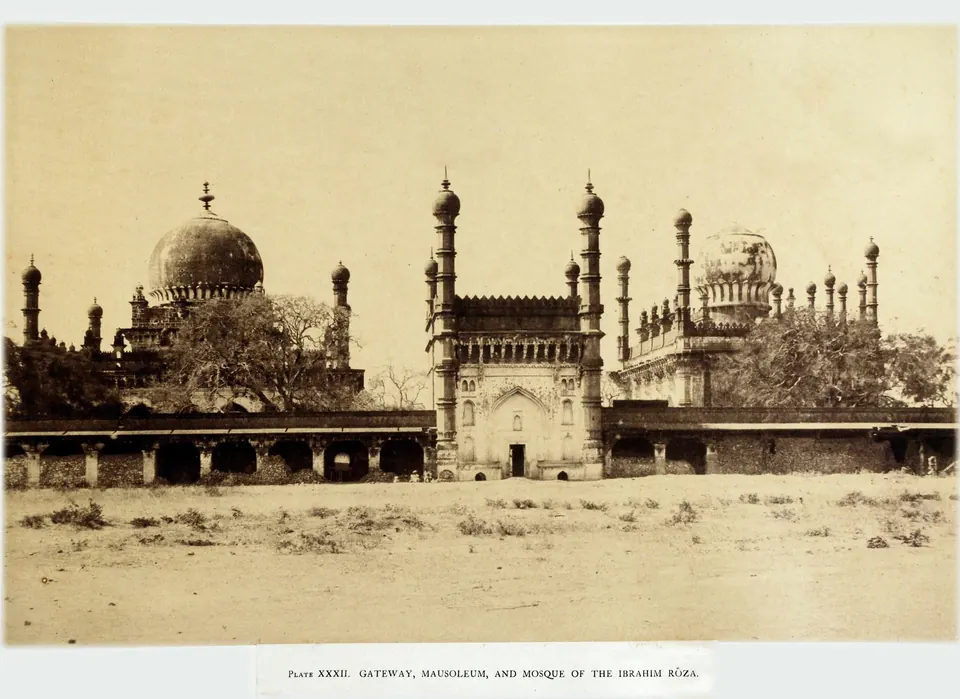
Ibrahim II built the Ibrahim Rauza for his queen Taj Sultana.13 He began a new city, Nauraspur, to the west, but it was never finished.1312148 Malik Ambar of Ahmadnagar plundered Nauraspur in 1624.12 Muhammad built his own tomb, the Gol Gumbaz.14
Conquest and decline
Aurangzeb besieged the city in 1686. Jadunath Sarkar writes that “Sunday, 12th September, 1686, saw the downfall of the Bijapur monarchy”.15 On that day Sikandar Adil Shah came out of the citadel to the emperor’s camp.16 A week later Aurangzeb rode into the fort and prayed in the Jama Masjid.17 He renamed the Mangali gate the Gate of Victory.17
According to Sarkar, “From a royal capital it became the seat of a provincial governor”.18 Two years after the conquest, a plague “swept away more than half its population”.18
Cousens adds that the city passed to Nizam-ul-Mulk in 1724, to the Peshwa in 1760 and to the Raja of Satara in 1818.19 It later became the headquarters of the British district of Bijapur.19 See Aurangzeb.
Footnotes
-
Henry Cousens, Bijapur and its Architectural Remains (Archaeological Survey of India, Imperial Series, Vol. XXXVII, 1916), p. 19 (archive.org (opens in a new tab)). ↩ ↩2 ↩3 ↩4
-
Cousens, Bijapur and its Architectural Remains (1916), p. 2 (archive.org (opens in a new tab)). ↩ ↩2 ↩3
-
Ferishta, tr. Briggs, Rise of the Mahomedan Power, Vol. III (1829), p. 134 (archive.org (opens in a new tab)). ↩
-
Narahari Gopalakristnamah Chetty, A Manual of the Kurnool District (1886), p. 28 (archive.org (opens in a new tab)). ↩
-
Sarkar, Aurangzib IV (1930), p. 151 (archive.org (opens in a new tab)). ↩
-
Cousens, Bijapur and its Architectural Remains (1916), p. 3 (archive.org (opens in a new tab)). ↩ ↩2 ↩3 ↩4
-
Cousens, Bijapur and its Architectural Remains (1916), p. 4 (archive.org (opens in a new tab)). ↩ ↩2 ↩3 ↩4 ↩5
-
Cousens, Bijapur and its Architectural Remains (1916), p. 22 (archive.org (opens in a new tab)). ↩ ↩2 ↩3
-
Cousens, Bijapur and its Architectural Remains (1916), p. 9 (archive.org (opens in a new tab)). ↩ ↩2 ↩3
-
Cousens, Bijapur and its Architectural Remains (1916), p. 28 (archive.org (opens in a new tab)). ↩ ↩2 ↩3
-
Muhammad Qasim Ferishta, tr. John Briggs, History of the Rise of the Mahomedan Power in India, Vol. III (1829), p. 143 (archive.org (opens in a new tab)). ↩
-
Cousens, Bijapur and its Architectural Remains (1916), p. 14 (archive.org (opens in a new tab)). ↩ ↩2 ↩3 ↩4
-
Cousens, Bijapur and its Architectural Remains (1916), p. 13 (archive.org (opens in a new tab)). ↩ ↩2
-
Cousens, Bijapur and its Architectural Remains (1916), p. 15 (archive.org (opens in a new tab)). ↩ ↩2
-
Jadunath Sarkar, History of Aurangzib, Vol. IV (2nd ed., 1930), p. 388 (archive.org (opens in a new tab)). ↩
-
Sarkar, Aurangzib IV (1930), p. 389 (archive.org (opens in a new tab)). ↩
-
Sarkar, Aurangzib IV (1930), p. 391 (archive.org (opens in a new tab)). ↩ ↩2
-
Sarkar, Aurangzib IV (1930), p. 392 (archive.org (opens in a new tab)). ↩ ↩2
-
Cousens, Bijapur and its Architectural Remains (1916), p. 18 (archive.org (opens in a new tab)). ↩ ↩2
Photos
 "Gateway, Mausoleum, and Mosque of the Ibrahim Roza" at Bijapur (Taylor and Fergusson, Architecture at Beejapoor, 1866, pl. XXXII)Historic photograph · 1866
 "Head of Ramraj": stone head found in the Taj Bauri at Bijapur, by tradition the effigy of Rama Raya set in the citadel wall (Cousens 1916, p. 9, fig. 4)Photograph · 1916
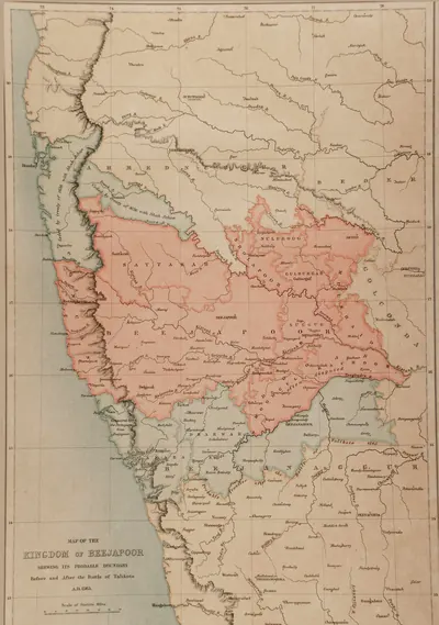 "Map of the Kingdom of Beejapoor, shewing its probable boundary before and after the Battle of Talikota, A.D. 1565" (Taylor and Fergusson, Architecture at Beejapoor, 1866, facing p. 1)Map · 1866
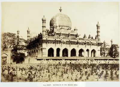 "Mausoleum of the Ibrahim Roza": the tomb of Ibrahim Adil Shah II at Bijapur (Taylor and Fergusson, Architecture at Beejapoor, 1866, pl. XXXIV)Historic photograph · 1866
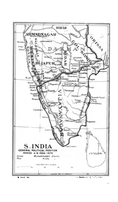 "S. India, General Political Position, Period A.D. 1336-1570" (Sewell 1900, to face p. 1 (PDF p. 38))Map · 1900
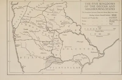 "The Five Kingdoms of the Deccan and Neighbouring States", with Golconda holding Telingana from Warangal to Rajahmundry and Kondavir (The Cambridge History of India, Vol. III (1928), Map 6)Map · 1928
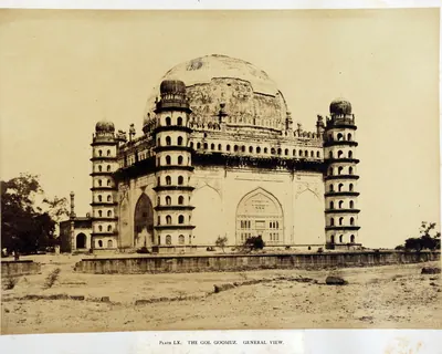 "The Gol Goomuz. General View": the tomb of Muhammad Adil Shah at Bijapur (Taylor and Fergusson, Architecture at Beejapoor, 1866, pl. LX)Historic photograph · 1866
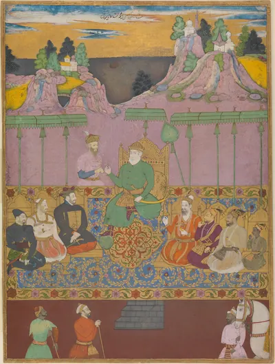 "The House of Bijapur": album leaf of the Adil Shahi dynasty by Kamal Muhammad and Chand Muhammad, Bijapur, about 1680 (Metropolitan Museum of Art)Other · c. 1680
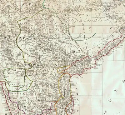 The Deccan in James Rennell's "Map of Hindoostan, or the Mogul Empire" (London, 1788): detail with Golconda, Telingana, Visiapour, Adoni, Dowlatabad, Berar and the CircarsMap · 1788
Related
Dynasties
People
Yusuf Adil Khan (Yusuf Adil Shah)
c. 1489–1510 CE
Founder of the Adil Shahi dynasty of Bijapur (r. about 1489–1510). He was a foreign-born officer of the Bahmani kings who governed the province of Bijapur with the title Adil Khan. He declared his independence in AH 895 (1489–90). In 1493 he defeated the Vijayanagara regent Timmaraja and took Mudgal and Raichur. This began a century of war over the Raichur doab.
Ismail Adil Shah
1510–1534 CE
Second Adil Shahi sultan of Bijapur (r. 1510–1534), the son of Yusuf Adil Khan. The fortresses of Raichur and Mudgal changed hands with Vijayanagara in his reign. In 1520 Krishnadevaraya besieged Raichur and routed his army on the Krishna. After Krishnadevaraya's death, Ismail took both forts back.
Ibrahim Adil Shah I
c. 1535–1558 CE
Fourth Adil Shahi sultan of Bijapur (r. 1535–1558), a younger son of Ismail Adil Shah. Invited by Bhoj Tirmal of Vijayanagara, he entered the Vijayanagara capital in 1535. His general Asad Khan then besieged Adoni, the first Bijapur attack on the fortress, which Ferishta says ended in a negotiated peace. In 1551–52 he lost Raichur and Mudgal to Aliya Rama Raya.
Ali Adil Shah I
c. 1558–1580 CE
Fifth Adil Shahi sultan of Bijapur (r. 1558–1580). He was first an ally of Aliya Rama Raya, but then joined the league of Deccan sultans that defeated and killed Rama Raya in January 1565. Afterwards he won back Raichur and Mudgal, took Adoni in 1568 and turned south against the Aravidu kings, besieging Penukonda. The date and details of that siege are disputed. He was the husband of Chand Bibi.
Ibrahim Adil Shah II
1580–1627 CE
Sixth Adil Shahi sultan of Bijapur (r. 1580–1627), nephew and successor of Ali Adil Shah I, called Jagat Guru. He was the patron of the historian Ferishta and the builder of the Ibrahim Rauza. In his reign Bijapur held Adoni against a siege of 1595–96. Early in the seventeenth century it took Kurnool from the last Hindu chief of the town. Heras places Ferishta's account of a failed Bijapur siege of Penukonda in these years.
Muhammad Adil Shah
1627–1656 CE
Seventh Adil Shahi sultan of Bijapur (r. 1627–1656), called Mahmud in some histories, and the builder of the Gol Gumbaz. He made peace with Shah Jahan in 1636 and then sent his armies into the Karnatak, with Shahji Bhonsle among the commanders. Bijapur took Jinji and Vellore, Penukonda (1652, by a Mackenzie manuscript) and the uplands of the Bellary and Anantapur country. It divided the Karnatak with Golconda's minister Mir Jumla.
Ali Adil Shah II
1656–1672 CE
Eighth Adil Shahi sultan of Bijapur (r. 1656–1672). Aurangzeb invaded the kingdom when he came to the throne, claiming that he was not Muhammad Adil Shah's son. His reign saw the rise of Shivaji and the rebellion of Siddi Jauhar, the Abyssinian governor of Kurnool. Royal campaigns brought the Kurnool province and the Raichur country back under control, before the Mughal treaties of 1666–68 cut down the kingdom.
Siddi Masud Khan
c. 1662–1688 CE
Abyssinian noble of Bijapur. By the Bellary gazetteer's count he was governor and jagirdar (land-grant holder) of Adoni from 1662 to 1687. From 1678 he was regent of the kingdom for the boy-king Sikandar Adil Shah. He built the Jama Masjid of Adoni, which its inscriptions date to AH 1079 (1666–67). Driven from the capital, he held Adoni as the last Bijapur stronghold in the Telugu country. He surrendered it to the Mughals, in 1688 according to Sarkar.
Sikandar Adil Shah
1672–1686 CE
Ninth and last Adil Shahi sultan of Bijapur (r. 1672–1686). He came to the throne as a small boy and reigned under regents: Khawas Khan, Bahlol Khan, and the Abyssinian Siddi Masud, jagirdar (land-grant holder) of Adoni. In his reign Shivaji marched through the Kurnool country to take Bijapur's Karnatak forts (1677), and the Raichur doab was ceded to the Marathas. Aurangzeb took Bijapur on 12 September 1686. Sikandar died a prisoner in 1700.
Asad Khan Lari
before 1549 CE
Turkish officer of Bijapur (died 1549), born Khusrau Aqa. He held Belgaum as a jagir (land grant) and was the chief minister and army commander of Ismail and Ibrahim I Adil Shah. In 1535–37 he led the first Bijapur attack on Adoni. He besieged the fort and surprised the camp of Venkatadri, Rama Raya's brother, who had come to relieve it.
Shahji Bhonsle
before 1664 CE
Maratha captain of hired soldiers and father of Shivaji. He served the Nizam Shahs of Ahmadnagar, and from 1636 the Adil Shahs of Bijapur. As second in command to Randaula Khan, he took part in Bijapur's conquest of the Karnatak. He was given a jagir (land grant) round Bangalore and Kolar, a country taken from the forebears of the Telugu poligars of Punganur. He kept a court at Bangalore and died in 1664. His son Vyankoji inherited his Karnatak jagir.
Siddi Jauhar (Salabat Khan)
before 1662 CE
Abyssinian officer of Bijapur who held Kurnool as his government and jagir (land grant) under Ali Adil Shah II. Given the title Salabat Khan, he besieged Shivaji in Panhala in 1660. Suspected of letting him escape, he withdrew to Kurnool, rose against the king in 1662 and was killed by his own followers. His son-in-law was Siddi Masud of Adoni.
References
Notes (0)
Sources (4)
Spotted an error on this page? Tell us
Last updated: